There are likely to be at least 50 deaths after a devastating outbreak of tornadoes that ripped through Kentucky and other U.S. states late Friday and early Saturday, Kentucky Governor Andy Beshear said.
“It’s devastating,” Beshear told a news conference early Saturday, adding that he had declared a state of emergency and activated 181 guardsmen from the National Guard.
“We believe our death toll from this event will exceed 50 Kentuckians and probably end up closer to 70 or 100 lost lives,” he said. “We will make it through this,” he added. “We will rebuild, we are strong, resilient people.”
Beshear said four tornadoes, one of which stayed on the ground for more than 200 miles after touching down, had swept through the state. Almost 60,000 Kentuckians had been left without power, he said.
The city of Mayfield had been “devastated,” he said, adding that a roof collapse and a candle factory had “resulted in mass casualties.”
Elsewhere, one person was dead and five were seriously injured when an apparent tornado struck the Monette Manor Nursing Home in Monette, Arkansas, Craighead County Judge Marvin Day said. He initially said two people had died.
At the same news conference, Kentucky Emergency Management Director Michael Dossett said the storm represented a “significant massive disaster event.
“All state resources are being brought to bear,” he said, adding that “it’ll be daybreak before we even realize the full magnitude of this event.”
Tornado warnings issued Friday also covered parts of Arkansas, Illinois, Missouri and Tennessee. Nearly 180,000 utility customers in those five states were without power early Saturday.
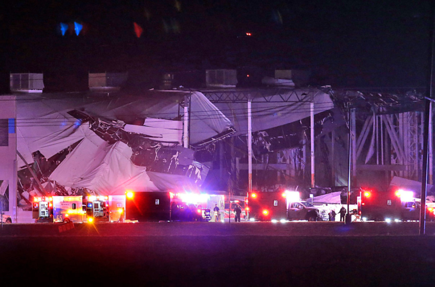
In Edwardsville, Illinois, outside St. Louis, there were multiple injuries after a 100 foot portion of a wall partially collapsed at an Amazon facility, officials with the Illinois Emergency Management Agency and Edwardsville Fire Department said.
The fire department said no deaths had been confirmed.
Edwardsville police said a search-and-rescue operation was ongoing.
Herb Simmons, the director of the St. Clair County Emergency Management Agency who spoke to NBC News from the scene, said that his agency received a call for mutual aid at 8:59 p.m.
“We are in rescue mode at this time,” he said.
Simmons said the site of the partial collapse is on the Amazon complex, but did not know which building it was, nor how many people were believed to be trapped inside.
He added that it was going to be a “long process” to determine exactly what had happened.
Amazon spokesperson Richard Rocha said the company was assessing the situation.
“The safety and well-being of our employees and partners is our top priority right now,” he said.
Illinois Gov. J.B. Pritzker activated the state’s Emergency Operations Center as a result of the severe weather. There have been multiple, unconfirmed reports of tornadoes, the emergency management agency said.
Damage in Tennessee, Missouri
A possible tornado also struck in Samburg, Tennessee, where the local fire department was severely damaged, the Obion County Sheriff’s Office said. It wasn’t clear if there were injuries.
Earlier, the National Weather Service also issued a tornado emergency for the Kentucky cities of Madisonville, Earlington and Nortonville. Such a designation signifies that “severe threat to human life is imminent,” catastrophic damage is likely, or that there’s reliable information that a tornado touched down.
In Missouri, two people were hospitalized, including one with “very critical injuries,” and a third person was injured following structural collapses, said Kyle Gaines with the St. Charles County Ambulance District.
Tornadic thunderstorms
The National Weather Service warned Friday night that “tornadic thunderstorms” were moving from eastern Missouri to Illinois Friday night as part of a line of unstable weather moving east.
The instability was created when warm, humid air from the Gulf of Mexico interacted with a cold front, federal forecasters said.
The extreme weather, including heavy downpours and some flooding, was expected from the Mississippi Valley, which includes many states along the Mississippi River, to the Ohio Valley.
There were 26 unconfirmed reports of tornadoes across five states, according to the National Weather Service.
Confirmation that a tornado has touched down takes time and often comes a day or more after the weather event because the National Weather Service uses in-person assessments after the worst weather has passed. The service examines how trees were uprooted or damaged as part of the process.
Weekend weather systems
Strong weather was expected to affect 35 million Americans this weekend, with heavy snow forecast in the Midwest, tornadoes possible in the South, and rain aiming for California.
A low-pressure system over the Central Plains was producing as much as 2 inches of snow an hour in the Minneapolis-St. Paul region Friday night. “Travel will be very difficult,” the weather service tweeted.
That front was expected to strengthen as it moves over the Great Lakes region Saturday and brings with it heavy snowfall and blustery winds, federal forecasters said.
Light snow and strong winds were expected overnight in Chicago, they said. Rain and high winds were forecasted for Detroit, where the National Weather Service warned residents to prepare for possible power outages.
Warm air was expected to move into the Eastern Seaboard on Saturday, producing record high temperatures for the date in some parts of the Mid-Atlantic, federal forecasters said.
The National Weather Service office that covers New York City said high temperatures in 60s were expected.
But the springlike weather will be short-lived: A cold front was forecasted to “sweep across the entire East Coast” late Saturday, bringing “sharply falling temperatures and sudden onset of blustery winds,” the weather service said in a forecast discussion Friday.
California was preparing for rain and snow as a storm was expected to strike the northern half of the state Saturday and then move south, bringing snow to the Sierra Nevada mountains and even to peaks in Southern California. Rain was forecast from the Bay Area to the border.
Federal forecasters in Oxnard, California, said as much as 2 feet of snow could fall Monday and Tuesday in mountain locations higher than 7,000 feet.
The National Weather Service office that covers Sacramento urged motorists to avoid traveling in the mountains.
The California governor’s Office of Emergency Services said residents up and down the state should prepare for “widespread moderate to heavy rain, mountain snow, gusty winds, and thunderstorms” through at least Tuesday.

