
Stay Informed: WCCO Weather App | Live Radars | Weather Page | Snow Emergencies
MINNEAPOLIS (WCCO) — A winter storm is rolling across Minnesota Sunday night, bringing widespread snow accumulation, plus slick roads and patchy, blowing snow through Monday morning.
WCCO Meteorologist Lisa Meadows says the snow began falling in western and southern Minnesota just after 4 p.m. The system reached the metro just after 7 p.m., and is expected to leave 2 to 4 inches of snow by Monday morning.
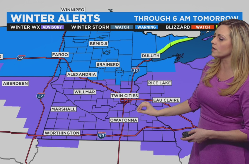
Central Minnesota is expected to get around 5 to 7 inches. That area, and the metro, are under a Winter Weather Advisory until 6 a.m. Monday.

(credit: CBS)
The National Weather Service issued an Airport Weather Warning in effect at Minneapolis-St. Paul International Airport until 11:45 p.m. Sunday due to the storm, which is expected to drop an inch of snow per hour in the metro for several hours.
After midnight in the metro and further south, there’s a window for freezing rain and ice accumulation until about 4 a.m., especially for areas between Redwood Falls and Red Wing to the south. Most of southern Minnesota could see anywhere between a half inch to 2 inches in snow accumulation by mid-Monday.
The Monday morning commute will be a rough one for folks north of the Interstate 94 corridor, where snow will keep falling into the late morning and early afternoon hours. A Winter Storm Warning has also been issued until 6 a.m. Monday. Seven to 9 inches of snow could fall by the time the system exits the northeast Monday evening. The Arrowhead is under a Blizzard Warning until 6 p.m. Monday.
In addition to the snow, strong wind gusts Sunday night and into Monday morning will complicate travel. Gusts of 30+ mph will be felt across the state.
Temperatures will stay Monday, with highs in the low 30s in the Twin Cities before another round of snow possible comes late Tuesday, and after that temperatures plummet.
Wednesday’s temps will be in the single digits in the Twin Cities — making it the coldest day since February. Subzero lows will also be widespread midweek through the weekend.