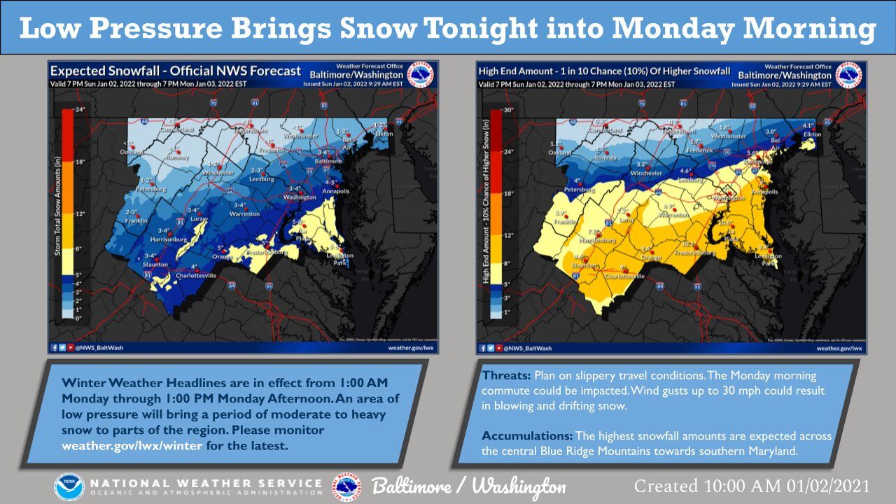
The National Weather Service has issued a Winter Storm Watch from 1 a.m. to 1 p.m. Monday for D.C. and points south of Interstate 66 and U.S. Route 50. Forecasters expect heavy snow late tonight through Monday afternoon, with total accumulations of between 3 and 6 inches possible.
Higher-than-average temperatures have made snowfall a bit of a rarity so far this season, but the D.C. region’s winter weather lovers might finally have something to get excited about.
A low pressure system developing over Southern Appalachia is poised to bring snow from the Blue Ridge to the coastal Chesapeake Bay starting Sunday night. Though last-minute shifts in the forecast could lead to locally higher or lower totals, snowfall will complicate Monday morning travel for commuters in the District, Northern Virginia and Southern Maryland.
“We’re going to be dealing with rates potentially on the border of 1/2 inch to an inch an hour at the peak of the storm, and with those kind of rates it’ll definitely cause some issues on the roadways,” said Connor Belak, a meteorologist at the National Weather Service. “Especially the elevated surfaces like bridges.”
The National Weather Service has issued a Winter Storm Watch from 1 a.m. to 1 p.m. Monday for D.C. and points south of Interstate 66 and U.S. Route 50. Forecasters expect heavy snow late Sunday night through Monday afternoon, with total accumulations of between three and six inches possible. The heaviest snowfall is predicted to be between 5 a.m. and 10 a.m.
The forecast for heavy snow was extended from its original perimeters to include areas in central and northern Maryland (parts of Baltimore, Montgomery County) and northern Virginia (Loudoun County) could see one to three inches.
Lesser totals are forecast to the west in portions of central and northwest Virginia, including Fauquier and Culpeper counties, where a Winter Weather Advisory instead called for 2 to 4 inches.
LWX expands area to include Winter Storm Watch valid at Jan 3, 1:00 AM EST till Jan 3, 1:00 PM EST https://t.co/2xP9xQbuvw pic.twitter.com/C2C3exrNTi
— Matt Ritter, WTOP Multimedia Meteorologist (@MetMattRitter) January 2, 2022

Monday’s forecast had called for little more than flurries a day ago, but a dramatic shift in computer models on Sunday morning has put the immediate D.C. region under a distinct risk for something much more significant.
The culprit — a rapidly deepening storm front moving out from the Tennessee Valley over the Carolinas — will bring moisture into the D.C. area from west to east after midnight. While a mix of rain and sleet could kick things off, overnight temperatures should be cool enough for a prolonged period of good ol’ snow lasting past daybreak.
“As the colder air continues to spill into the region from the north, that rain will switch over to sleet and then eventually from sleet as the air continues to get colder and colder will change over to snow,” NBC Washington meteorologist Ryan Miller told WTOP.
But as with so many winter storms in recent memory, there’s a catch: Models are hinting at a tight gradient of snowfall accumulation just north of the nation’s capital, meaning small nudges in the system’s path throughout Sunday could lead to big differences in exactly how much falls — and where. The precise setup of heavier snow bands are also notoriously difficult to predict, and that too could be a determining factor.
“This is a type of storm that is going to be on the coast and there’s going to be a tight gradient between where the precipitation falls and where there’s going to be nothing,” Miller said.
The take-away is that the forecast is likely to change somewhat, but whatever results will more than likely prove a headache for anyone hitting the road on Monday morning. Plan for slippery conditions on streets, steps, sidewalks and driveways regardless of how much snow ends up falling.
“Right around lunchtime tomorrow I think things will quiet down,” Miller told WTOP.
A low pressure system has trended north and west over the last 24 hours, which will now bring the potential for heavy snowfall into portions of our area late tonight into Monday morning. For all the latest details and impacts, visit https://t.co/5RyZgpeTAT pic.twitter.com/Qo7ZFTwW5V
— NWS Baltimore-Washington (@NWS_BaltWash) January 2, 2022
Forecast:
Sunday: Mostly cloudy. Rain showers end by early afternoon. Mild in the morning but turning drastically colder late in the day. Highs near 60.
Sunday night: Snow and sleet starting after midnight. Local accumulations between 3 and 6 inches, with higher amounts south of the District, and lower north and west. Lows in the upper 20s to mid 30s.
Monday: Snow or a wintry mix, heavy at times. Gradual clearing after late morning. Highs in the mid to upper 30s.
Tuesday: Sunshine. A bit warmer, with highs in the upper 30s to mid 40s.
Wednesday: Partly cloudy and breezy. Highs in the upper 30s to mid 40s.
Thursday: Mostly cloudy. Highs in the upper 40s.


