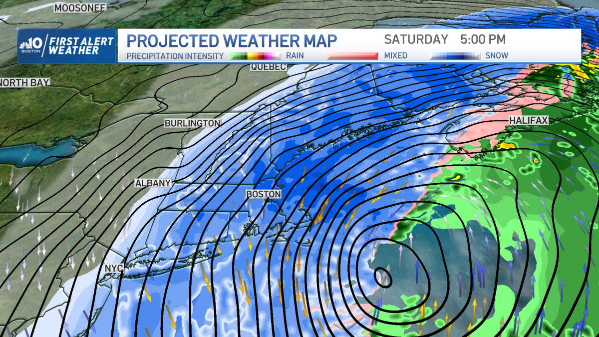
A blizzard warning was issued early Friday morning by the National Weather Service for areas along the coastline. Our First Alert Weather team believes blizzard conditions will be realized from the coast of Maine to the coast of New Hampshire, eastern Massachusetts, including the Boston area, south shore and the south coast as well.
That last verified blizzard in Boston was on March 13, 2018. What qualifies as a verified blizzard? Three consecutive hours or more with considerable falling or blowing snow that reduces visibility to a quarter of a mile or less and frequent gusts or sustained winds at or over 35 mph.
Blizzard vs. snowstorm
Blizzard, Nor’easter, Bomb-Cyclone, call it what you want, this one looks like the biggest storm of the season. As forecast models update and our weather team filters through the noise, numbers, and charts, we continue to bring you the latest updates on this storm.
[Friday 430 AM] Now is the time to prepare! Here are our latest thoughts on a strong coastal storm that will impact S New England tomorrow. A Blizzard Warning is in effect where confidence is highest that strong winds & heavy snow will lead to low visibility. #MAwx #RIwx #CTwx pic.twitter.com/euE8uODSGN
— NWS Boston (@NWSBoston) January 28, 2022
When will the snow start in Boston?
Friday overnight through Saturday night we see heavy snow and blizzard conditions across eastern New England. The height of the storm will be the predawn hours Saturday, through mid afternoon.
No one should be on the roads between 5 a.m. and 3 p.m. (give or take an hour or two). Plow trucks will have a hard time keeping up with the rapid snowfall rates of 2-4” per hour at times in eastern New England. Visibility will be near zero and the snow will be blowing and drifting with the fluffy consistency.
The snow remains heavy until Saturday evening, wrapping up west to east rapidly by dinnertime Saturday. The center of the storm heads towards Nova Scotia and will cross into Canada by dawn on Sunday.
How much snow will we get in Massachusetts?
Forecast models overnight have come in with some ridiculous snow possibilities over the last few runs. Looking at the data, our team has updated and increased the snow totals.
Boston, north shore, south shore, upper cape, Martha’s Vineyard, Providence, to Worcester, Portland, & Merrimack Valley with 18-24+”. Around the same is possible on the outer Cape & Nantucket to Hartford & Augusta.
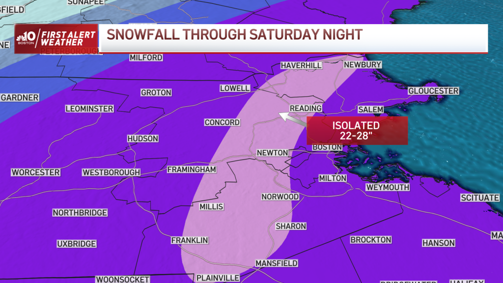
Isolated totals of 22-28” likely where there is significant snow banding in parts of the Merrimack Valley, and along 128. This band may shift farther south, depending on where the bands set up. Thundersnow is also likely with these intense bands.
For reference, here are the top 5 biggest Boston snowstorms (two-day total): Top spot is February 17-18, 2002 with 27.6”; February 6-7, 1978 with 27.1”; April 1-2, 1997 with 25.4”; February 8-9, 2013 with 24.9”; and 5th place is January 26-27, 2015 with 24.4”.
Will there be widespread power outages in New England?
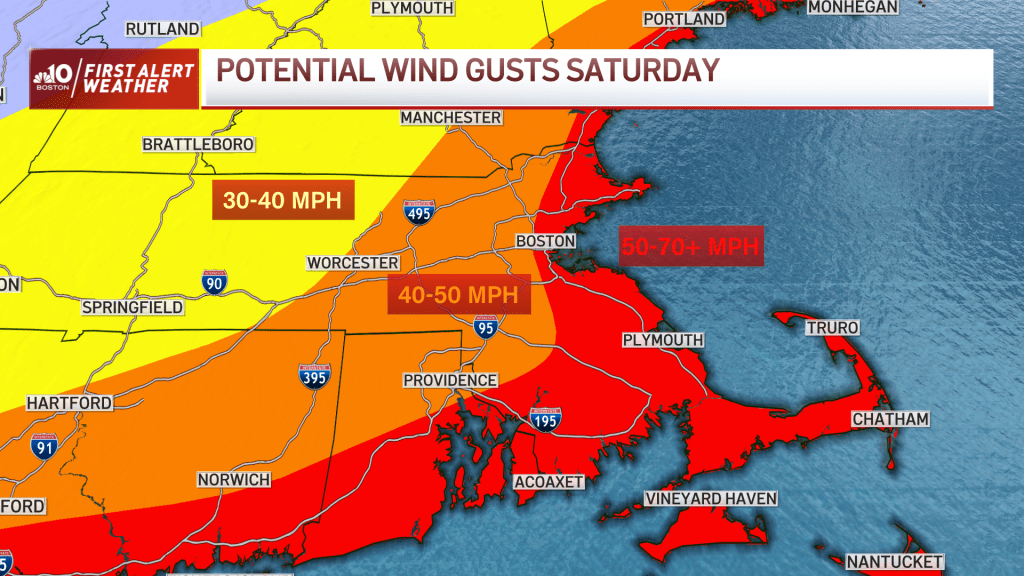
Winds intensify Saturday morning and stay strong all afternoon. Gusts from the northeast will push 40-50 mph along 128, 495, to Worcester. 30-40 mph gusts across Springfield, and Vermont to interior New Hampshire. At the coast of Maine, New Hampshire, and all of eastern Massachusetts to southern Rhode Island, we will see gusts 50-70 mph or greater in isolated spots.
This will contribute to tree damage, shingles off roofs and power outages. Those without power will have another serious problem with the bitter cold after the storm. Temps will stay below freezing through Monday afternoon. Lows in the teens Saturday night and Sunday night, and highs in the mid 20s Sunday.
What areas will see coastal flooding?
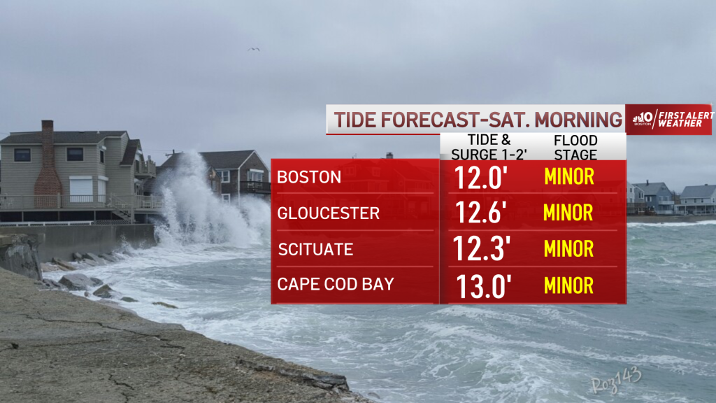
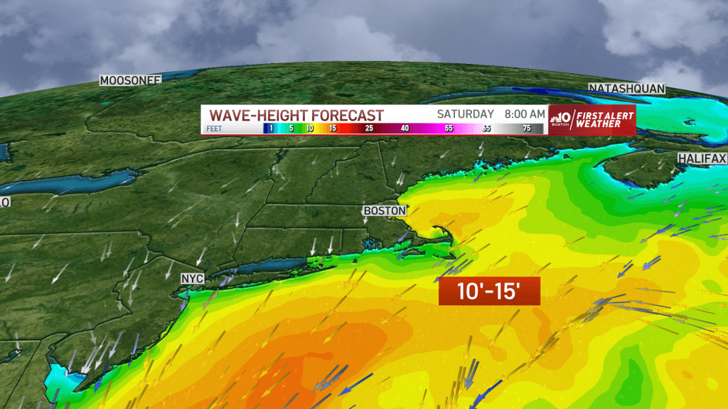
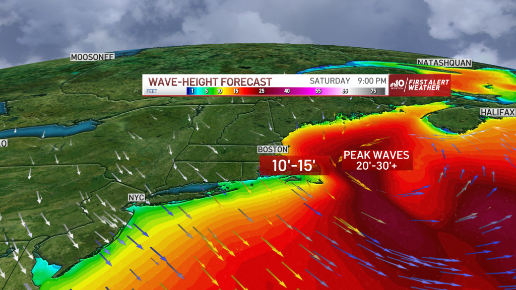
Our tides are increasing astronomically into the weekend. A storm surge of 1-3 feet is forecast, with the high tides Saturday morning, Saturday evening, and Sunday morning.
Our waves will be 10-15’ with a northeast wind during the Saturday morning high tide=minor flooding. Waves will increase to 20-30’ with a northeast, north wind during the Saturday evening high tide=minor to moderate flooding.
With the wind from the north, the water in Cape Cod Bay may remain elevated so minor flooding is expected there for the Sunday morning high tide with waves 10-20 feet. Beach erosion will be significant all over the New England coastline. Waves that hit houses will freeze as temps will be cold with this storm, even at the coast.
10-day outlook
Cold temperatures and quiet weather prevails for Sunday as storm clean up gets underway. We have a nice warm up for midweek and into the end of the week. Highs may be in the 50s with rain showers by Thursday and Friday!
Stay tuned to the First Alert weather team for more updates on this storm and to the February thaw to follow.

