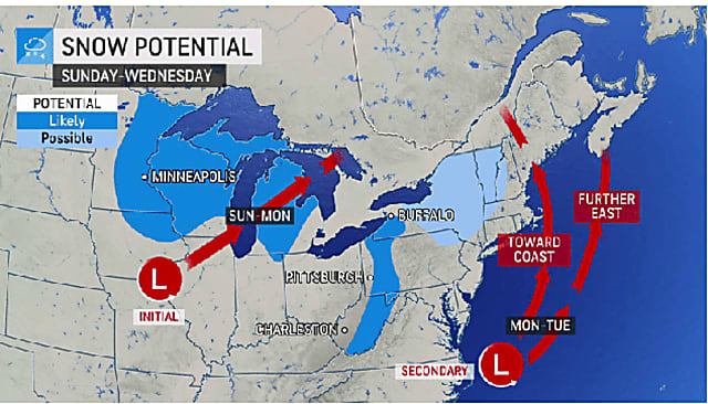
Two scenarios have emerged surrounding the path of a potential Nor’easter that could cause disruptions and delays for Thanksgiving traveling.
The storm is expected to arrive early Monday morning, Nov. 22.
“We could be looking at a huge mess and a real wrench in holiday travel,” said AccuWeather Chief Meteorologist Jon Porter.
Some parts of the region are expected to see snowfall from the system, according to AccuWeather. (See first image above.)
Snowfall totals could be more significant if the storm tracks closer to the coast. (Click on the second image above.)
If the storm tracks farther off the coast, less snowfall is expected. (Click on the third image above.)
For the rest of this week, expect some head-spinning changes in temperatures.
Temperatures will top off in the mid 60s on Thursday, Nov. 18, with the daytime high across the region being generally about 10 degrees above average. The mercury could even be near 70 degrees in some spots.
The topsy turvy trend will continue on Friday, Nov. 19 with temperatures plummeting again, with the daytime high expected to be only in the mid 40s.
“A cold front is expected to trigger showers later on Thursday, Thursday night, and Friday morning before the roller coaster makes a drastic dip once again,” AccuWeather Senior Meteorologist Carl Babinski said.
The dip in temperatures to end the week will be triggered by a new round of rain and showers overnight Thursday into Friday.
After showers taper off before daybreak Friday, skies will become sunny with a high temperature in the mid 40s.
Saturday, Nov. 20 will be mostly cloudy with a high in the mid 40s.
Temperatures will climb a bt on Sunday, Nov. 21 as the storm system approaches, with a high in the mid 50s under mostly cloudy skies.
The storm currently is expected to arrive sometime overnight Sunday into Monday morning.
This continues to be a developing story. Check back to Daily Voice for updates.
Click here to sign up for Daily Voice’s free daily emails and news alerts.


